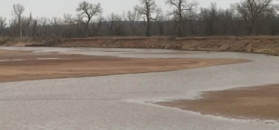
Feds Seizing 116 Miles Of Ranchers’ Land … And Moving Texas-Oklahoma Border
 The Bureau of Land Management may have pulled scores of armed agents away from the Bundy Ranch, but another range war appears to be brewing along the Texas and Oklahoma border.
Texas rancher Tommy Henderson has been dealing with BLM agents for the past 30 years, and he and other ranchers appear to be losing their property rights battle. Although many in elementary school were taught that the border between Texas and Oklahoma is the Red River, the issue is far more complicated than that, according to the BLM and a court ruling handed down when Henderson lost 140 acres of land in a failed lawsuit against the federal agency three decades ago.
BLM is now using the lawsuit ruling as a precedent to seize even more land along a 116-mile stretch of the river, which the agency claims never belonged to Texas in the first place. Ranchers beg to differ.
“They’re wanting to take the boundaries that the courts placed here and extend those east and west to the forks of the river north of Vernon and east to the 98th Meridian which is about 20 miles east of us,” he told Texas Farm Bureau News.
As regulations on our lives increase, it is apparent that we are losing our historic freedoms.
If the BLM is successful in its bid to seize the 90,000 acres, it would substantially alter the boundaries between the two states. The fight boils down to the difference between avulsion and accretion, and the way the river moves. Since the Louisiana Purchase of 1803 there has been some controversy about the exact boundary between Texas and Oklahoma along the Red River. The river has moved over time and the boundary is supposed to be noted as the vegetation line along the south side of the waterway.
Both states use different semantics to define the boundary, according to the Americas Freedom Fighters website. Oklahoma state statute defines avulsion in a different manner than both the United States government and Texas.
“How can BLM come in and say, ‘Hey, this isn’t yours’?” Henderson asked. “… Our family paid taxes for over 100 years on this place. We’ve got a deed to it. But yet they walked in and said it wasn’t ours?”
Story continues below video
He added, “Originally, here the river was out there where it is now and it eroded and accreted up to here, and then it eroded and accreted back. Well, [BLM’s] interpretation is that it eroded up to here but avulsed back. So when you listen to them it is always erosion to the south because the property line follows it then, but it’s always avulsion when it goes north. So the boundary can move south but it can never move back north.”
Other ranchers in the region are watching the fight very closely, knowing their property could be impacted. One such rancher is Scott Carpenter of Nacona, Texas.
“We have numerous places that have been in our family for over a hundred of years, and you hate to see land that people’s worked hard for would lose. As producers we are always on a defense. We have to make decisions to try to help ourselves to help one another.”
What do you think? Let us know in the comments below.
Sign up for Off The Grid News’ weekly email and stay informed about the issues important to you
 2292
2292  43
43  1Google +
 1
1  1
1  2
2 Off The Grid News Better Ideas For Off The Grid Living
No comments:
Post a Comment